A new educator's first foray into modern media

Category: EdTech Inquiry

SkySafari: Finding Place in the Universe

What Is SkySafari?

SkySafari is a free app that uses augmented reality and a massive historical and knowledge database to allow the user to learn about every star, constellation, and astral body in the sky at all times of day and year, and compare it to what was happening minutes, hours, days, or years ago! I think this counts as an environmental app for place-based learning, especially because stories and legends about the stars and the cosmos are so important to the culture of a place. We see different stars here than people do in Australia, and experience the motion of the planets differently than somebody in Colorado, for instance.  The way we see the stars is very specific to place, and learning more about how and why we see them that way is important to understanding the place you’re in.

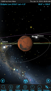
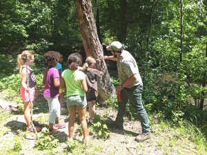
Close-up Selection view of Mars, including its moons! Image by kyu3 on Photozou, under CC BY-SA 2.5.

How to use it for education

There are a ton of tools on this app. Using Compass, the phone’s screen turns into a planetarium, with an overlay of stars and other astral bodies that updates as you turn 360 degrees or change the angle of your phone up toward the sky or down toward the ground. The phone orients to the four compass directions, and uses GPS to locate the phone’s latitude and longitude, as well as the exact local time. At any time of day or night, the user can select any star in the sky that is shown on the app, and not only learn its name and what constellation it’s in, but using the Selection tool will open an information page with everything known about that astral body and its history. The International Space Station, all the planets in our solar system, Pluto, the Sun, and the Moon are also included and have a ton of info available. Using the Time tool, the user can see what was happening in the cosmos at any time over the last several decades. Using these tools, students can explore the ‘night sky’ at any time of day, wherever they are – including in the classroom!

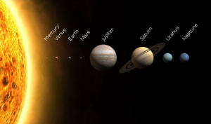
The solar system lies along a flat plane called the ecliptic, which you can discover using the orbit of the planets, sun, and moon over time. Image by PlanetUser on Wikimedia Commons (under CC BY-SA 3.0).

A cool lesson with this app could be using paper cut-outs and string to represent the movement of certain stars or planets over a year. This could apply to art, science, or even English (explaining the principles of astronomy to make sense of Shakespeare’s “star-crossed lovers” maybe?)! In Social Studies, you could have a ‘day at the planetarium’ by dimming the lights in your classroom and using the app to mark the constellations on the wall to link them to Greek and Roman mythology. You could even find some Indigenous stories about the stars and bring those viewpoints into the conversation!

There are some other cool features as well, like the Night setting (switches the phone’s display to all red light for night viewing), the Tonight tool (shows the rising and setting time of planets, satellites, and notable stars coming up that night), and Notifications (pops up when an interesting event like a planetary transit, comet sighting, or ISS visible, is about to happen).

Pros
  • Free (although there are pop-ups advertising in-app purchases, these are easily dismissed)
  • Cross-platform (Available on Play Store for Android and App Store on Apple devices)
  • Versatile, with many tools for students to explore
  • Works day and night, any time of year
  • Contains seemingly limitless extra information on every visible object in the night sky
  • Can go ‘back in time’ using the Time function to understand planet/star movements
  • Unlike some stargazing apps, it has the outer planets and Pluto
Cons
  • Uses WiFi, but would require data if outside or out of WiFi range
  • Does not contain every star in the sky (but has most of the easily-visible ones)
  • The download is big, and will take up precious space on students’ devices
  • Some pre-knowledge of where to find things will help, but is not really necessary once you start exploring!

LifeScanner: DNA in Action

What is LifeScanner?

LifeScanner is an app that works with the Barcode of Life Database (BOLD Systems) at the University of Guelph. It includes a database of all the specimens collected all over the planet, as well as kits that allow users to send in their own specimens. I’d like to propose that it has the potential to be used not just to identify species, but as a tool to address essential questions related to biology and inter-curricular inquiries.

Photo by Mike Beauregard on Flickr (under CC BY 2.0).

How can it be used for education?

The app itself can be used to identify species, look up animals that live in your area, and learn about the biodiversity in your backyard, region, or country. With the collection kits, a class could collect and send in specimens to BOLD for DNA barcoding. By exploring the app, students learn more about some of the applications of DNA sequencing and what it can be used to do, like identify food fraud, discover new species, and track the effects of climate change on animal distributions. A class field trip to a park or beach could include using the app to make and check off a list of commonly found animals, helping the students improve their powers of observation. Or, conversely, students could photograph as many animals as they can find, then check with the app to see which ones they did not find, and hypothesize why they were not found. ELL or second-language students could pick an animal, research it, and give a presentation of what they found, expanding their vocabulary.

Using the kits, students are engaged in exploration to find a specimen, develop photography skills to get a set of diagnostic photos, practice hypothesis development when trying to identify the animal as best they can, and participate in real-life citizen science by contributing their specimens to the worldwide BOLD database, which they can see on their app! Students could also be asked to investigate food fraud by collecting samples of meat or seafood that they suspect is not what is labelled (sushi is great for this).

Pros
  • App is free!
  • Gets students outside exploring their environment
  • Interactive way to learn about genetic technology
  • Students can actively contribute to a body of scientific knowledge
  • Fun way to learn about the diversity of local species
  • Teaches practical skills of observation, photography, search terms in databases
  • Students learn about proper food labelling, and the prevalence of food fraud
Cons
  • Currently only available on Apple devices (iPhone, iPad, etc.)
  • Collection kits are expensive ($50 for 4 collection kits)
  • Animal specimens need to be small enough to fit in the tube or a piece has to be cut off, so the database comprises mostly invertebrate species (i.e. great for bugs or tidepooling, but not birding)
  • To collect whole animals, they do have to be sacrificed. This is a moral dilemma that should be discussed as a class, and students should not be required to collect specimens.
Curricular Areas

LifeScanner applications could be used for Science 9/10 (exploring local biodiversity), Life Sciences 11 (DN sequencing, biodiversity, and taxonomy), social studies (food labelling), art (photography, biodiversity), and ELL/second languages (learning French/Spanish words for animals, practicing communication), and math (point sampling, survey methods).


Citizen Science and Place-Based Learning: eBird

I am what you would call a pre-amateur birder. I like birds, and from my time as a marine biologist I can easily identify several birds that are common on the water, as well as some that are more common on land. I don’t own a pair of binoculars or a telephoto lens, but I do own a Sibley bird guide which I sometimes bring on hikes. But after exploring eBird, I am really excited about using this app in my classes!

Barn Owl by seabamirum on Flickr (under CC BY 2.0)

What is eBird?

eBird is a citizen science bird-reporting app that is produced and curated by the Cornell Lab of Ornithology (CLO), and is supported by Merlin Bird ID (reviewed here by my partner Brigitte). It is free to download on all platforms (supported by a browser edition), can be used offline, and comes in over 30 languages. It has a built-in bird identification interface that links to Merlin, which can be used offline. It’s a way for birdwatchers to keep track of their birding finds, with metrics available to help you track your sightings compared to previous years and months. Once the phone enters WiFi reception again, all these sightings are sent directly to a database monitored by CLO, which anybody can access.

Want to find the best birding sites around Chiang Mai, Thailand? Want to know the hotspots in your area for really rare birds to check off your list? Want to see what time of year people see the most pelicans in your area? All can be found with the database. Scientists use the database to create, modify, and track range maps and migration routes on large and small scales. They can even use the data that this app has generated already to study the impacts of climate change on birds! The best part is that all users can follow one another, so students can look at local users to find good spots for birding. As a teacher, you can also track what your students are seeing (or whether they’re getting their walks in) by following their accounts. See below for an introductory video from the CLO YouTube channel:


How can it be used for education?

As an educational app, eBird has amazing potential for several different curricular areas including science, art, social studies, and even math! It gives an opportunity for students to:

  • Engage with their environment and have an excuse to take their phone on a walk
  • Participate in friendly competition among students for the most birds/rarest birds/most excursions, etc.
  • Contribute in a real way to a body of knowledge that is actually used by scientists and users all over the world
  • Be introduced to the biological and mathematical ideas of point-counts, population ecology, statistical likelihood, survey methods, and identification.
  • Get outside with friends and learn more about what is special about their backyards!
Pros
  • App is free, ad-free, and available on all platforms
  • Easy and intuitive to use
  • Number and length of birding expeditions can be curated by the teacher by following student accounts
  • Can be used with Merlin to identify birds from a photo
Cons
  • Merlin Bird ID must also be installed to use identification service
  • Bird lists (eBird) and ID packages (Merlin) must be downloaded in WiFi range before heading into the field
  • A baseline level of bird knowledge is required by the teacher to check students’ work

Environmental Apps for Place-Based Learning

Photo taken by Virginia State Parks on Flickr, under Creative Commons license CC BY 2.0.

The four of us (Kay, Kat, Caitie, Kate, and Brigitte) are looking into ways to incorporate place-based learning into our classes. We have diverse teachable areas, but we’re all interested in helping our students get more in-touch with nature and with the local species in their area. in my personal experience (Kat), knowing more about the natural world around me helps me feel more at home in a place, and better able to connect to it. As we get more and more involved in technology in the classroom, we all wanted to ‘take a step outside’, so to speak, and think of ways to use technology to get more in touch with sense of place.

The following is a list of nature apps that we know of, and might be exploring this term:

iNaturalist/Seek

Lifescanner

Merlin Bird ID

Picture Insect

eBird

Leafsnap

Seaweed Sorter

And more that we will find over the next week or so! Our current plan is to investigate each app and rate them on usability, quality of database, value-for-price, and number of applications to a class or unit. This will get tweaked in the coming weeks as we talk more about our plans, so stay tuned!


Kahoot! In Classrooms – Pros and Cons

A Quick Run-Down

Kahoot! is a game-based learning platform that can be used for formative assessment in classrooms. It is becoming popular in secondary schools and has potential to be useful for all teaching disciplines, and even out-of-class activities like coaching, field trips, and anywhere that students have their phones (which is, let’s be honest, all the time). So far, Kahoot! has gained a billion players in the six years it’s been around.

In Kahoot!, teachers create a quiz and students are able to access and answer the quiz questions on a mobile device or tablet. Each student’s score depends on both who answers first, and how long it took to answer (time elapsed).


A recent study showed that students given either a single Kahoot! game or several games in a few weeks had the SAME level of increased engagement and interest in the class (Wang 2015).


Pros

  • It doesn’t have to be a competition between individuals. Students can work in teams.


  • Adding some good-natured competition is a good way to keep students engaged and encourage them to have fun with classmates they might not talk to normally.


  • It lets the educator get a quick ‘pulse’ from your class in terms of comprehension, preconceived notions about a topic, or how students feel they are progressing.


Cons   

  • You need to set it up and make sure all your students have access to a phone or tablet. If some students don’t have access to a mobile device, you will have to provide tablets.


  • You need wifi (or data) to use it, and if you’re in a place where wifi is spotty, it might not work. James even mentioned that sometimes a team can lose the game just because they’re sitting in the corner of the room with the worst reception, which isn’t fair.


  • Students can create their own usernames, which leaves it open to inappropriate language. That said, you can turn them away if they try to sign up with a name you don’t approve of.

Let’s Give It a Try!